GPS Photo Map: See Where Every Photo Was Taken
Turn your event gallery into an interactive map. Every photo automatically positioned based on GPS data from the camera — browse your memories by location, not just time.
What Is the GPS Photo Map?
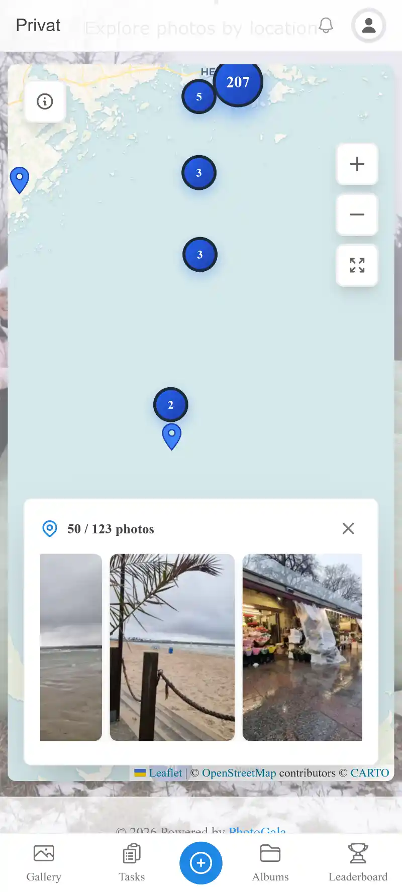
The GPS Photo Map is an interactive map layer built into every Photogala event gallery. When guests take photos with location services enabled on their smartphone, the GPS coordinates are embedded in the image's EXIF metadata. Photogala reads these coordinates automatically and positions each photo on a beautiful, zoomable map.
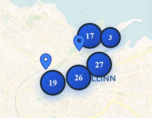
Instead of scrolling through hundreds or thousands of photos in a flat timeline, you can explore your event geographically. Click on a map marker to see exactly which photos were taken at that spot. When multiple photos cluster in one area — like the church entrance or the dance floor — the map intelligently groups them into clusters that expand as you zoom in.
This transforms the way you relive events. A destination wedding in Tuscany becomes a visual journey through vineyards, hilltop ceremonies, and rustic reception halls. A corporate retreat unfolds across conference rooms, team-building sites, and dinner venues. The map tells the story of movement and place that a timeline alone cannot capture.
How the GPS Photo Map Works
No setup required from guests. If their phone records GPS data in photos (most do by default), the map builds itself automatically.
Guests Upload Photos
Guests take photos with their smartphone camera, which automatically embeds GPS coordinates, altitude, and direction in the image's EXIF metadata. They upload these photos to your Photogala event gallery via the QR code or event link — no app installation needed.
GPS Data Extracted Automatically
Photogala's backend reads the EXIF GPS tags from every uploaded image in real-time. Latitude, longitude, and accuracy data are extracted, validated, and stored alongside the photo. Invalid or missing GPS data is handled gracefully — those photos simply appear in the gallery without a map pin.
Browse Photos on the Interactive Map
The event gallery includes a map view that displays all geotagged photos as markers. Zoom in to see individual photo locations, or zoom out to see intelligent clusters. Click any marker or cluster to open a photo preview. Filter by time range, guest, or album to narrow down the map view.
Where the GPS Photo Map Shines
Any event that spans multiple locations benefits enormously from a geographic photo view. Here are the most popular use cases.
Multi-Venue Weddings
Modern weddings often span three or more locations: the ceremony at a church or outdoor venue, cocktail hour in a garden, and the reception at a hall or restaurant. The GPS map lets couples and guests relive each chapter of the day by clicking through locations on the map.
- ✓Church ceremony photos clustered at the altar location
- ✓Garden cocktail photos grouped around the outdoor bar area
- ✓Reception hall photos showing the dance floor, dinner tables, and photo booth
Destination Events
When your event takes place in a beautiful destination — a beach resort, a European city, or a mountain lodge — guests naturally explore and photograph the surroundings. The GPS map captures this wanderlust and turns scattered sightseeing snapshots into a coherent visual travel diary.
- ✓Resort pool, beach, and lobby photos mapped across the property
- ✓City exploration photos showing guests discovering local landmarks
- ✓Pre-wedding excursion photos from boat trips or hiking trails
Corporate Retreats & Offsites
Multi-day corporate events with sessions spread across conference centers, breakout rooms, restaurants, and team-building venues generate photos from many locations. The GPS map gives organizers a complete visual record of every activity location and helps create compelling post-event reports.
- ✓Conference hall presentations and breakout session photos
- ✓Team-building activity photos from outdoor challenge courses
- ✓Networking dinner and awards ceremony photos at the restaurant venue
Adventure Events & Festivals
Music festivals, scavenger hunts, charity runs, and adventure races unfold across large areas. The GPS map shows the full scope of the event — every stage, every checkpoint, every food truck — creating a comprehensive visual map that no single photographer could capture alone.
- ✓Festival stage areas with crowd photos from different vantage points
- ✓Race route photos showing participants at various checkpoints
- ✓Food and vendor area photos scattered across the festival grounds
Privacy & Control
Location data is sensitive. Photogala gives both organizers and guests full control over how GPS data is handled.
GPS Data Is Always Optional
Guests are never required to share location data. If a photo doesn't contain GPS coordinates — because the guest disabled location services or the camera didn't record them — the photo still appears in the gallery normally, just without a map marker. There is zero friction for guests who prefer not to share their location.
Guests Control Their Camera Settings
Every smartphone allows users to disable location tagging in their camera app settings. Guests who prefer privacy can turn off location services for their camera before the event, and their photos will upload without any GPS data. This is a standard phone feature that Photogala fully respects.
Organizer Can Disable the Map
Event organizers have full control over whether the GPS map feature is visible to guests. If the map doesn't make sense for your event or you prefer a simpler gallery experience, you can disable it entirely from the event settings. GPS data is still extracted for your records but the map tab won't appear for guests.
Unique in the Market
We surveyed every major event photo sharing app on the market — from simple gallery tools to full event platforms — and none of them offer an interactive GPS photo map. This isn't a minor differentiator; it's an entirely new way to experience event photography that only Photogala provides.
Most event apps treat photos as a flat stream sorted by upload time or organized into albums. They completely ignore the rich location data that modern smartphones embed in every photo. Photogala is the first to surface this data in a meaningful, beautiful way that genuinely enhances how people browse and relive their event memories.
For events that span multiple locations — which is the majority of weddings, corporate events, and festivals — the GPS photo map transforms the gallery from a simple photo dump into an interactive journey. It's the feature that makes guests say 'I've never seen anything like this' and it's the feature that makes your event stand out.
GPS Photo Map vs. Alternatives
See how Photogala's GPS Photo Map compares to what other event photo platforms offer.
| Feature | Photogala | Alternatives |
|---|---|---|
| Interactive photo map | Full interactive map with clusters, zoom, and filters | Not available |
| Automatic GPS extraction | Automatic from EXIF data, zero setup | Not available |
| Location-based browsing | Click map markers to view photos from that location | Not available |
| Cluster view for dense areas | Smart clustering that expands on zoom | Not available |
| Privacy controls | Map toggle, fully optional | Basic or none |
Interactive photo map
Full interactive map with clusters, zoom, and filters
Not available
Automatic GPS extraction
Automatic from EXIF data, zero setup
Not available
Location-based browsing
Click map markers to view photos from that location
Not available
Cluster view for dense areas
Smart clustering that expands on zoom
Not available
Privacy controls
Map toggle, fully optional
Basic or none
Get started with Photogala
Collect every photo and video from your event — pick the package that fits.
Buy now, use anytime. The event duration starts after the first 10 photos are uploaded, not from the purchase date.
Plus
Collect every guest photo in one beautiful gallery.
- High Quality Uploads
- Photo WallNEW
- Unlimited Albums
- Downloads (Single & Bulk)NEW
- Dark Mode
- Photo Liking
- Custom QR Codes
- QR Template DownloadsNEW
- Invitation QR DownloadsNEW
- Smart Albums(from Premium)
- Sharing & Comments(from Premium)
- Photo Challenges (Full Suite)(from Premium)
- Points & Leaderboard(from Premium)
- +9 more in higher tiers
Premium
The full experience — guests engage, you get the best photos.
- High Quality Uploads
- Photo Wall
- Social Features (Share, Comment, Like)NEW
- Unlimited Albums & Smart AlbumsNEW
- Photo Challenges (Full Suite)NEW
- Points & LeaderboardNEW
- Achievements & ImportNEW
- Downloads (Single & Bulk)
- Moderation & Team RolesNEW
- Full Branding (Gallery & QR)NEW
- +10 more features
- AI Tools (Filter & Face Recognition)(from Deluxe)
- GPS Map View(from Deluxe)
- Real Rewards(from Deluxe)
- Photo Wall Logo(from Deluxe)
Deluxe
AI-powered, fully branded, completely hands-free.
- High Quality Uploads
- Photo Wall (with Logo)NEW
- Social Features (Share, Comment, Like)
- Unlimited Albums & Smart Albums
- Photo Challenges (Full Suite)
- Points & Leaderboard
- Achievements & Real RewardsNEW
- AI Tools (Filter & Face Recognition)NEW
- Downloads (Single & Bulk)
- Moderation & Team Roles
- +14 more features
Starter (free of charge)
Your moments, your stage, create your first digital photo gallery completely free of charge.
- High Quality Uploads
- Unlimited Albums
- Dark Mode
- Photo Liking
- Custom QR Codes
- Photo Wall(from Plus)
- Downloads (Single & Bulk)(from Plus)
- QR Template Downloads(from Plus)
- Invitation QR Downloads(from Plus)
Uploader Definition: All guests who upload at least one photo or video count as uploaders. Unlimited guests can still view the gallery.
Fair Use Storage: Storage is sized for normal event usage. Reach out if you need unusually large galleries.
Frequently Asked Questions
How does the map get photo locations?
What if a photo doesn't have GPS data?
Can guests disable location tracking?
Does the map work for indoor events?
Which plan includes the GPS map?
Related Features
Discover more powerful tools for your event.
Ready to Get Started?
Create your event in minutes. No credit card required.